


GRANDRIS (19 km - D. 733 m)

Thomasdanielle
User
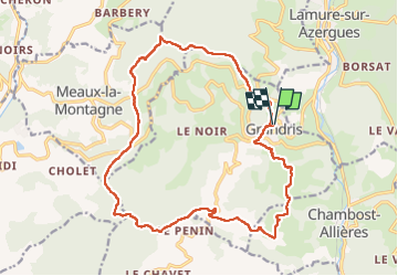

Length
19.2 km

Max alt
869 m

Uphill gradient
733 m
Km-Effort
29 km

Min alt
385 m

Downhill gradient
733 m
Boucle
Yes
Creation date :
2023-05-22 07:25:02.0
Updated on :
2023-05-23 15:45:42.479
6h35
Difficulty : Very difficult

FREE GPS app for hiking
 SityTrail
IGN / Geographical institutes
SityTrail Plus
The world is yours!
About
Trail Walking of 19.2 km to be discovered at Auvergne-Rhône-Alpes, Rhône, Grandris. This trail is proposed by Thomasdanielle.
Description
D/A : Parking proche de la mairie
Positioning
Country:
France
Region :
Auvergne-Rhône-Alpes
Department/Province :
Rhône
Municipality :
Grandris
Location:
Unknown
Start:(Dec)
Start:(UTM)
614229 ; 5099492 (31T) N.
Comments