


J1

JPS73
User
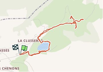

Length
6.3 km

Max alt
1483 m

Uphill gradient
201 m
Km-Effort
9 km

Min alt
1350 m

Downhill gradient
203 m
Boucle
Yes
Creation date :
2023-05-22 12:11:53.414
Updated on :
2023-05-22 14:51:30.938
1h36
Difficulty : Medium

FREE GPS app for hiking
 SityTrail
IGN / Geographical institutes
SityTrail Plus
The world is yours!
About
Trail Walking of 6.3 km to be discovered at Auvergne-Rhône-Alpes, Upper Savoy, La Clusaz. This trail is proposed by JPS73.
Positioning
Country:
France
Region :
Auvergne-Rhône-Alpes
Department/Province :
Upper Savoy
Municipality :
La Clusaz
Location:
Unknown
Start:(Dec)
Start:(UTM)
303713 ; 5087643 (32T) N.
Comments