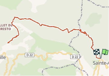
Ste Agnes Peille

jlrayon
User

Length
17.4 km

Max alt
882 m

Uphill gradient
773 m
Km-Effort
28 km

Min alt
578 m

Downhill gradient
773 m
Boucle
Yes
Creation date :
2014-12-10 00:00:00.0
Updated on :
2014-12-10 00:00:00.0
5h11
Difficulty : Easy

FREE GPS app for hiking
 SityTrail
IGN / Geographical institutes
SityTrail Plus
The world is yours!
About
Trail Walking of 17.4 km to be discovered at Provence-Alpes-Côte d'Azur, Maritime Alps, Sainte-Agnès. This trail is proposed by jlrayon.
Description
Ste Agnes Peille
Positioning
Country:
France
Region :
Provence-Alpes-Côte d'Azur
Department/Province :
Maritime Alps
Municipality :
Sainte-Agnès
Location:
Unknown
Start:(Dec)
Start:(UTM)
376010 ; 4851062 (32T) N.
Comments