


Ignau-Vaychis

crognon
User
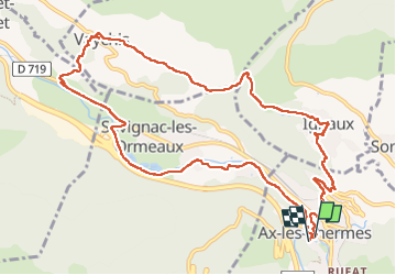

Length
13.3 km

Max alt
1009 m

Uphill gradient
436 m
Km-Effort
19.1 km

Min alt
665 m

Downhill gradient
430 m
Boucle
Yes
Creation date :
2023-05-23 08:41:32.055
Updated on :
2023-05-23 14:37:29.881
5h55
Difficulty : Medium

FREE GPS app for hiking
 SityTrail
IGN / Geographical institutes
SityTrail Plus
The world is yours!
About
Trail Walking of 13.3 km to be discovered at Occitania, Ariège, Ax-les-Thermes. This trail is proposed by crognon.
Positioning
Country:
France
Region :
Occitania
Department/Province :
Ariège
Municipality :
Ax-les-Thermes
Location:
Unknown
Start:(Dec)
Start:(UTM)
404851 ; 4730241 (31T) N.
Comments