


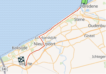
Oostende Veurne

JanDeprez
User

Length
31 km

Max alt
30 m

Uphill gradient
216 m
Km-Effort
34 km

Min alt
-3 m

Downhill gradient
229 m
Boucle
No
Creation date :
2014-12-10 00:00:00.0
Updated on :
2014-12-10 00:00:00.0
5h00
Difficulty : Medium

FREE GPS app for hiking
 SityTrail
IGN / Geographical institutes
SityTrail Plus
The world is yours!
About
Trail Walking of 31 km to be discovered at Flanders, West Flanders, Ostend. This trail is proposed by JanDeprez.
Positioning
Country:
Belgium
Region :
Flanders
Department/Province :
West Flanders
Municipality :
Ostend
Location:
Oostende
Start:(Dec)
Start:(UTM)
494412 ; 5675991 (31U) N.
Comments