


roc de l'aigle

Mascart
User
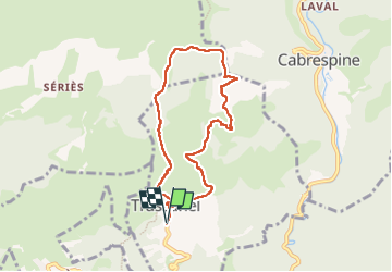

Length
7.5 km

Max alt
713 m

Uphill gradient
338 m
Km-Effort
12 km

Min alt
440 m

Downhill gradient
337 m
Boucle
Yes
Creation date :
2023-05-23 11:37:04.551
Updated on :
2023-05-23 16:12:45.943
2h32
Difficulty : Medium

FREE GPS app for hiking
 SityTrail
IGN / Geographical institutes
SityTrail Plus
The world is yours!
About
Trail Walking of 7.5 km to be discovered at Occitania, Aude, Trassanel. This trail is proposed by Mascart.
Description
départ trassanel et retour via GR 36
Positioning
Country:
France
Region :
Occitania
Department/Province :
Aude
Municipality :
Trassanel
Location:
Unknown
Start:(Dec)
Start:(UTM)
454276 ; 4799205 (31T) N.
Comments