


Gorges du Bruyant Bec de l'aigle

MICDURAND
User
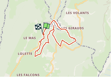

Length
8.1 km

Max alt
1138 m

Uphill gradient
317 m
Km-Effort
12.5 km

Min alt
912 m

Downhill gradient
373 m
Boucle
Yes
Creation date :
2023-05-23 06:46:05.443
Updated on :
2023-05-24 05:50:25.668
2h03
Difficulty : Medium

FREE GPS app for hiking
 SityTrail
IGN / Geographical institutes
SityTrail Plus
The world is yours!
About
Trail Walking of 8.1 km to be discovered at Auvergne-Rhône-Alpes, Isère, Lans-en-Vercors. This trail is proposed by MICDURAND.
Positioning
Country:
France
Region :
Auvergne-Rhône-Alpes
Department/Province :
Isère
Municipality :
Lans-en-Vercors
Location:
Unknown
Start:(Dec)
Start:(UTM)
704359 ; 5002808 (31T) N.
Comments