


MN du 24 mai autour du Rocher de Comboire

Emelle
User
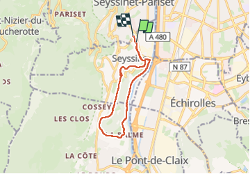

Length
11.1 km

Max alt
482 m

Uphill gradient
310 m
Km-Effort
15.2 km

Min alt
221 m

Downhill gradient
306 m
Boucle
No
Creation date :
2023-05-24 06:24:32.353
Updated on :
2023-05-25 12:31:19.027
2h38
Difficulty : Easy

FREE GPS app for hiking
 SityTrail
IGN / Geographical institutes
SityTrail Plus
The world is yours!
About
Trail Nordic walking of 11.1 km to be discovered at Auvergne-Rhône-Alpes, Isère, Seyssins. This trail is proposed by Emelle.
Positioning
Country:
France
Region :
Auvergne-Rhône-Alpes
Department/Province :
Isère
Municipality :
Seyssins
Location:
Unknown
Start:(Dec)
Start:(UTM)
711505 ; 5004793 (31T) N.
Comments