


Nice etap1

taguette
User
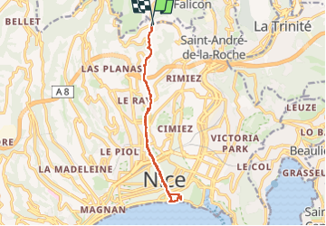

Length
14.1 km

Max alt
322 m

Uphill gradient
348 m
Km-Effort
18.7 km

Min alt
6 m

Downhill gradient
344 m
Boucle
Yes
Creation date :
2023-05-23 15:17:08.198
Updated on :
2023-05-24 10:39:36.388
3h23
Difficulty : Medium

FREE GPS app for hiking
 SityTrail
IGN / Geographical institutes
SityTrail Plus
The world is yours!
About
Trail Walking of 14.1 km to be discovered at Provence-Alpes-Côte d'Azur, Maritime Alps, Nice. This trail is proposed by taguette.
Positioning
Country:
France
Region :
Provence-Alpes-Côte d'Azur
Department/Province :
Maritime Alps
Municipality :
Nice
Location:
Unknown
Start:(Dec)
Start:(UTM)
360182 ; 4844841 (32T) N.
Comments