


Col du soulor

chasle
User
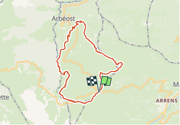

Length
16.8 km

Max alt
1602 m

Uphill gradient
799 m
Km-Effort
27 km

Min alt
948 m

Downhill gradient
800 m
Boucle
Yes
Creation date :
2023-05-25 15:53:55.895
Updated on :
2023-05-25 15:54:42.003
6h13
Difficulty : Medium

FREE GPS app for hiking
 SityTrail
IGN / Geographical institutes
SityTrail Plus
The world is yours!
About
Trail Walking of 16.8 km to be discovered at Occitania, Hautespyrenees, Arbéost. This trail is proposed by chasle.
Positioning
Country:
France
Region :
Occitania
Department/Province :
Hautespyrenees
Municipality :
Arbéost
Location:
Unknown
Start:(Dec)
Start:(UTM)
723382 ; 4760079 (30T) N.
Comments