


250523 Annecy

mzonzon05
User
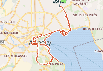

Length
14.4 km

Max alt
557 m

Uphill gradient
214 m
Km-Effort
17.2 km

Min alt
445 m

Downhill gradient
213 m
Boucle
Yes
Creation date :
2023-05-25 10:28:28.237
Updated on :
2023-05-25 17:01:29.701
4h59
Difficulty : Very easy

FREE GPS app for hiking
 SityTrail
IGN / Geographical institutes
SityTrail Plus
The world is yours!
About
Trail Walking of 14.4 km to be discovered at Auvergne-Rhône-Alpes, Upper Savoy, Annecy. This trail is proposed by mzonzon05.
Description
Découverte d'Annecy par ses plages et ses rues touristiques.
Un régal quand il n'y a pas trop de monde.
Photos

Positioning
Country:
France
Region :
Auvergne-Rhône-Alpes
Department/Province :
Upper Savoy
Municipality :
Annecy
Location:
Annecy-le-Vieux
Start:(Dec)
Start:(UTM)
278260 ; 5088503 (32T) N.
Comments