


2023-05-26_00h30m21_28127-15675317-2 (2)

daniellebou
User
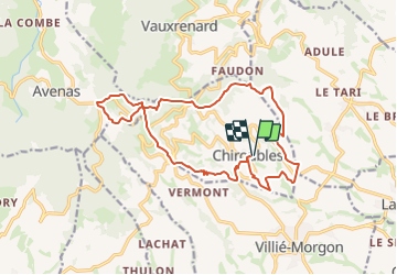

Length
16.9 km

Max alt
763 m

Uphill gradient
654 m
Km-Effort
26 km

Min alt
286 m

Downhill gradient
650 m
Boucle
Yes
Creation date :
2023-05-25 22:30:22.014
Updated on :
2023-09-14 20:58:39.828
5h49
Difficulty : Very difficult

FREE GPS app for hiking
 SityTrail
IGN / Geographical institutes
SityTrail Plus
The world is yours!
About
Trail Walking of 16.9 km to be discovered at Auvergne-Rhône-Alpes, Rhône, Chiroubles. This trail is proposed by daniellebou.
Positioning
Country:
France
Region :
Auvergne-Rhône-Alpes
Department/Province :
Rhône
Municipality :
Chiroubles
Location:
Unknown
Start:(Dec)
Start:(UTM)
628675 ; 5115515 (31T) N.
Comments