


Bourrignon - Le Mont - Les Bruyères - Refuge du Cerneux et retour par le Mont

patrickbeyrath
User
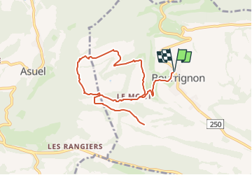

Length
9 km

Max alt
920 m

Uphill gradient
335 m
Km-Effort
13.5 km

Min alt
704 m

Downhill gradient
336 m
Boucle
Yes
Creation date :
2023-05-26 05:45:02.638
Updated on :
2023-05-26 05:57:24.308
3h03
Difficulty : Easy

FREE GPS app for hiking
 SityTrail
IGN / Geographical institutes
SityTrail Plus
The world is yours!
About
Trail On foot of 9 km to be discovered at Jura, District de Delémont, Bourrignon. This trail is proposed by patrickbeyrath.
Positioning
Country:
Switzerland
Region :
Jura
Department/Province :
District de Delémont
Municipality :
Bourrignon
Location:
Unknown
Start:(Dec)
Start:(UTM)
367498 ; 5250852 (32T) N.
Comments