


Leugny

bayet
User
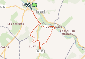

Length
6.5 km

Max alt
289 m

Uphill gradient
112 m
Km-Effort
8 km

Min alt
222 m

Downhill gradient
112 m
Boucle
Yes
Creation date :
2023-05-26 08:38:39.839
Updated on :
2023-05-26 08:43:14.995
1h49
Difficulty : Medium

FREE GPS app for hiking
 SityTrail
IGN / Geographical institutes
SityTrail Plus
The world is yours!
About
Trail Walking of 6.5 km to be discovered at Bourgogne-Franche-Comté, Yonne, Leugny. This trail is proposed by bayet.
Positioning
Country:
France
Region :
Bourgogne-Franche-Comté
Department/Province :
Yonne
Municipality :
Leugny
Location:
Unknown
Start:(Dec)
Start:(UTM)
528298 ; 5280860 (31T) N.
Comments