


bbq

Orres
User
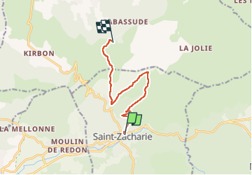

Length
9.1 km

Max alt
642 m

Uphill gradient
548 m
Km-Effort
15.2 km

Min alt
273 m

Downhill gradient
187 m
Boucle
No
Creation date :
2023-05-26 07:03:15.535
Updated on :
2023-05-26 10:35:16.736
2h35
Difficulty : Difficult

FREE GPS app for hiking
 SityTrail
IGN / Geographical institutes
SityTrail Plus
The world is yours!
About
Trail Walking of 9.1 km to be discovered at Provence-Alpes-Côte d'Azur, Var, Saint-Zacharie. This trail is proposed by Orres.
Positioning
Country:
France
Region :
Provence-Alpes-Côte d'Azur
Department/Province :
Var
Municipality :
Saint-Zacharie
Location:
Unknown
Start:(Dec)
Start:(UTM)
719442 ; 4807076 (31T) N.
Comments