


Levens Mont Cima

taguette
User
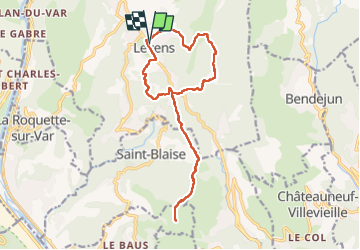

Length
17.7 km

Max alt
867 m

Uphill gradient
785 m
Km-Effort
28 km

Min alt
479 m

Downhill gradient
783 m
Boucle
Yes
Creation date :
2023-05-25 06:17:21.188
Updated on :
2023-05-26 12:45:26.407
4h51
Difficulty : Difficult

FREE GPS app for hiking
 SityTrail
IGN / Geographical institutes
SityTrail Plus
The world is yours!
About
Trail Walking of 17.7 km to be discovered at Provence-Alpes-Côte d'Azur, Maritime Alps, Levens. This trail is proposed by taguette.
Positioning
Country:
France
Region :
Provence-Alpes-Côte d'Azur
Department/Province :
Maritime Alps
Municipality :
Levens
Location:
Unknown
Start:(Dec)
Start:(UTM)
358419 ; 4856568 (32T) N.
Comments