


Utelle

taguette
User
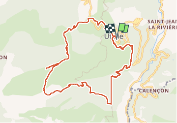

Length
13.1 km

Max alt
1185 m

Uphill gradient
795 m
Km-Effort
24 km

Min alt
420 m

Downhill gradient
798 m
Boucle
Yes
Creation date :
2023-05-26 06:28:13.002
Updated on :
2023-05-26 12:45:31.97
4h21
Difficulty : Difficult

FREE GPS app for hiking
 SityTrail
IGN / Geographical institutes
SityTrail Plus
The world is yours!
About
Trail Walking of 13.1 km to be discovered at Provence-Alpes-Côte d'Azur, Maritime Alps, Utelle. This trail is proposed by taguette.
Positioning
Country:
France
Region :
Provence-Alpes-Côte d'Azur
Department/Province :
Maritime Alps
Municipality :
Utelle
Location:
Unknown
Start:(Dec)
Start:(UTM)
359395 ; 4864060 (32T) N.
Comments