


Stevenson 2023.05.24

José Leveau
User

Length
8.3 km

Max alt
1239 m

Uphill gradient
299 m
Km-Effort
11.8 km

Min alt
983 m

Downhill gradient
143 m
Boucle
No
Creation date :
2023-05-24 12:31:04.688
Updated on :
2024-12-14 02:03:33.597
2h03
Difficulty : Difficult

FREE GPS app for hiking
 SityTrail
IGN / Geographical institutes
SityTrail Plus
The world is yours!
About
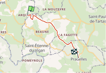
Trail Walking of 8.3 km to be discovered at Auvergne-Rhône-Alpes, Haute-Loire, Rauret. This trail is proposed by José Leveau .
Positioning
Country:
France
Region :
Auvergne-Rhône-Alpes
Department/Province :
Haute-Loire
Municipality :
Rauret
Location:
Unknown
Start:(Dec)
Start:(UTM)
565145 ; 4961826 (31T) N.
Comments