


SityTrail - col de mené

raymondfn
User
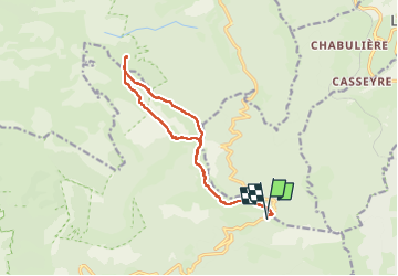

Length
13.6 km

Max alt
1672 m

Uphill gradient
533 m
Km-Effort
21 km

Min alt
1396 m

Downhill gradient
564 m
Boucle
Yes
Creation date :
2023-05-27 17:20:39.17
Updated on :
2023-05-27 17:26:33.693
4h43
Difficulty : Very difficult

FREE GPS app for hiking
 SityTrail
IGN / Geographical institutes
SityTrail Plus
The world is yours!
About
Trail Walking of 13.6 km to be discovered at Auvergne-Rhône-Alpes, Drôme, Châtillon-en-Diois. This trail is proposed by raymondfn.
Positioning
Country:
France
Region :
Auvergne-Rhône-Alpes
Department/Province :
Drôme
Municipality :
Châtillon-en-Diois
Location:
Treschenu-Creyers
Start:(Dec)
Start:(UTM)
705928 ; 4959345 (31T) N.
Comments