


GR6 2è part. Etp 9 Ners (bivouac) - Arpaillargue

pcugnod
User
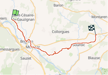

Length
25 km

Max alt
161 m

Uphill gradient
232 m
Km-Effort
28 km

Min alt
63 m

Downhill gradient
264 m
Boucle
No
Creation date :
2023-05-28 05:58:45.0
Updated on :
2023-05-28 14:49:23.37
6h04
Difficulty : Difficult

FREE GPS app for hiking
 SityTrail
IGN / Geographical institutes
SityTrail Plus
The world is yours!
About
Trail Walking of 25 km to be discovered at Occitania, Gard, Martignargues. This trail is proposed by pcugnod.
Positioning
Country:
France
Region :
Occitania
Department/Province :
Gard
Municipality :
Martignargues
Location:
Unknown
Start:(Dec)
Start:(UTM)
594519 ; 4875409 (31T) N.
Comments