


Jamioulx

vlentma
User
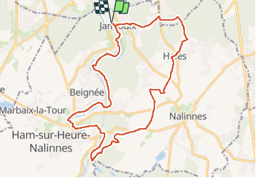

Length
19.4 km

Max alt
232 m

Uphill gradient
279 m
Km-Effort
23 km

Min alt
122 m

Downhill gradient
279 m
Boucle
Yes
Creation date :
2023-05-28 11:42:24.0
Updated on :
2023-05-28 15:11:31.507
3h17
Difficulty : Medium

FREE GPS app for hiking
 SityTrail
IGN / Geographical institutes
SityTrail Plus
The world is yours!
About
Trail Walking of 19.4 km to be discovered at Wallonia, Hainaut, Ham-sur-Heure-Nalinnes. This trail is proposed by vlentma.
Positioning
Country:
Belgium
Region :
Wallonia
Department/Province :
Hainaut
Municipality :
Ham-sur-Heure-Nalinnes
Location:
Unknown
Start:(Dec)
Start:(UTM)
600306 ; 5578909 (31U) N.
Comments