


saorge la baragne

tosan
User
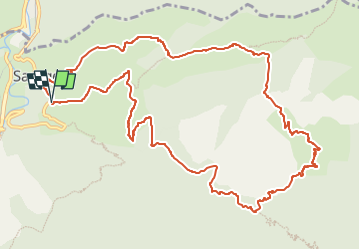

Length
14.8 km

Max alt
1226 m

Uphill gradient
1048 m
Km-Effort
29 km

Min alt
441 m

Downhill gradient
1050 m
Boucle
Yes
Creation date :
2023-05-28 16:48:36.718
Updated on :
2023-05-28 16:48:38.579
6h32
Difficulty : Very difficult

FREE GPS app for hiking
 SityTrail
IGN / Geographical institutes
SityTrail Plus
The world is yours!
About
Trail Walking of 14.8 km to be discovered at Provence-Alpes-Côte d'Azur, Maritime Alps, Saorge. This trail is proposed by tosan.
Positioning
Country:
France
Region :
Provence-Alpes-Côte d'Azur
Department/Province :
Maritime Alps
Municipality :
Saorge
Location:
Unknown
Start:(Dec)
Start:(UTM)
384084 ; 4871235 (32T) N.
Comments