


2023-05-28_20h22m08_ae77bf7817c9d6a0c0cd9b692a071c33

kephas
User
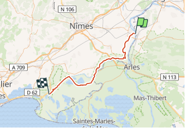

Length
63 km

Max alt
11 m

Uphill gradient
218 m
Km-Effort
66 km

Min alt
-5 m

Downhill gradient
225 m
Boucle
No
Creation date :
2023-05-28 18:22:08.739
Updated on :
2023-09-03 18:24:44.648
13h20
Difficulty : Medium

FREE GPS app for hiking
 SityTrail
IGN / Geographical institutes
SityTrail Plus
The world is yours!
About
Trail Cycle of 63 km to be discovered at Occitania, Gard, Beaucaire. This trail is proposed by kephas.
Positioning
Country:
France
Region :
Occitania
Department/Province :
Gard
Municipality :
Beaucaire
Location:
Unknown
Start:(Dec)
Start:(UTM)
632616 ; 4851543 (31T) N.
Comments