


Beaune_Monne_Fredet

jagarnier
User GUIDE
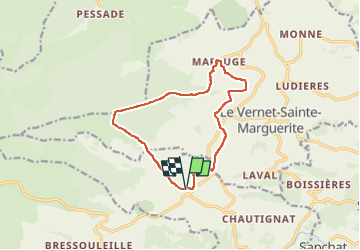

Length
12.5 km

Max alt
1246 m

Uphill gradient
363 m
Km-Effort
17.4 km

Min alt
1011 m

Downhill gradient
356 m
Boucle
Yes
Creation date :
2023-05-29 06:46:57.278
Updated on :
2023-05-30 05:15:50.448
3h45
Difficulty : Medium

FREE GPS app for hiking
 SityTrail
IGN / Geographical institutes
SityTrail Plus
The world is yours!
About
Trail Walking of 12.5 km to be discovered at Auvergne-Rhône-Alpes, Puy-de-Dôme, Murol. This trail is proposed by jagarnier.
Description
Au pied des Monts Dore, une randonnée sur le plateau sillonné de ruisseaux, entre pâturages et forêts de conifères.
Photos

Positioning
Country:
France
Region :
Auvergne-Rhône-Alpes
Department/Province :
Puy-de-Dôme
Municipality :
Murol
Location:
Unknown
Start:(Dec)
Start:(UTM)
493715 ; 5048773 (31T) N.
Comments