


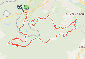
Baden Baden - rando des "hüttes" vers château Yburg

Bart2015
User


5h21
Difficulty : Very difficult

FREE GPS app for hiking
 SityTrail
IGN / Geographical institutes
SityTrail Plus
The world is yours!
About
Trail Walking of 15.8 km to be discovered at Baden-Württemberg, Baden-Baden. This trail is proposed by Bart2015.
Description
Randonnée qui parcoure de nombreux sentiers menant à une diversité de "hüttes" toutes plus belles les unes que les autres, souvent l'occasion d'une petite halte. Au bout des chemins, le château Yburg, hélas non visitable ...
Bonne rando ...
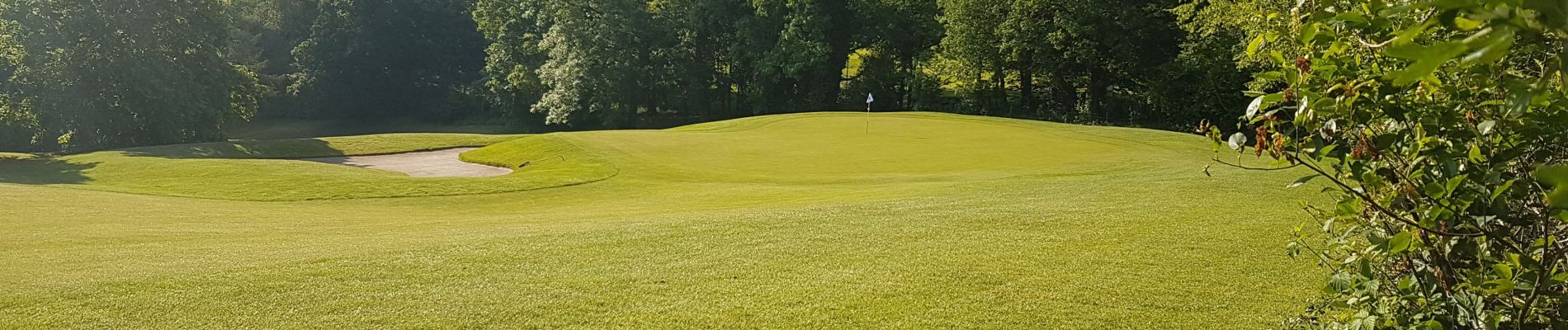
Photos
 "
data-pinterest-text="Pin it"
data-tweet-text="share on twitter"
data-facebook-share-url="https://www.sitytrail.com/en/trails/3679347-unknown--baden-baden-x-rando-des-xhuttesx-vers-chateau-yburg-/?photo=1#lg=1&slide=1"
data-twitter-share-url="https://www.sitytrail.com/en/trails/3679347-unknown--baden-baden-x-rando-des-xhuttesx-vers-chateau-yburg-/?photo=1#lg=1&slide=1"
data-googleplus-share-url="https://www.sitytrail.com/en/trails/3679347-unknown--baden-baden-x-rando-des-xhuttesx-vers-chateau-yburg-/?photo=1#lg=1&slide=1"
data-pinterest-share-url="https://www.sitytrail.com/en/trails/3679347-unknown--baden-baden-x-rando-des-xhuttesx-vers-chateau-yburg-/?photo=1#lg=1&slide=1">
"
data-pinterest-text="Pin it"
data-tweet-text="share on twitter"
data-facebook-share-url="https://www.sitytrail.com/en/trails/3679347-unknown--baden-baden-x-rando-des-xhuttesx-vers-chateau-yburg-/?photo=1#lg=1&slide=1"
data-twitter-share-url="https://www.sitytrail.com/en/trails/3679347-unknown--baden-baden-x-rando-des-xhuttesx-vers-chateau-yburg-/?photo=1#lg=1&slide=1"
data-googleplus-share-url="https://www.sitytrail.com/en/trails/3679347-unknown--baden-baden-x-rando-des-xhuttesx-vers-chateau-yburg-/?photo=1#lg=1&slide=1"
data-pinterest-share-url="https://www.sitytrail.com/en/trails/3679347-unknown--baden-baden-x-rando-des-xhuttesx-vers-chateau-yburg-/?photo=1#lg=1&slide=1">
 "
data-pinterest-text="Pin it"
data-tweet-text="share on twitter"
data-facebook-share-url="https://www.sitytrail.com/en/trails/3679347-unknown--baden-baden-x-rando-des-xhuttesx-vers-chateau-yburg-/?photo=2#lg=1&slide=2"
data-twitter-share-url="https://www.sitytrail.com/en/trails/3679347-unknown--baden-baden-x-rando-des-xhuttesx-vers-chateau-yburg-/?photo=2#lg=1&slide=2"
data-googleplus-share-url="https://www.sitytrail.com/en/trails/3679347-unknown--baden-baden-x-rando-des-xhuttesx-vers-chateau-yburg-/?photo=2#lg=1&slide=2"
data-pinterest-share-url="https://www.sitytrail.com/en/trails/3679347-unknown--baden-baden-x-rando-des-xhuttesx-vers-chateau-yburg-/?photo=2#lg=1&slide=2">
"
data-pinterest-text="Pin it"
data-tweet-text="share on twitter"
data-facebook-share-url="https://www.sitytrail.com/en/trails/3679347-unknown--baden-baden-x-rando-des-xhuttesx-vers-chateau-yburg-/?photo=2#lg=1&slide=2"
data-twitter-share-url="https://www.sitytrail.com/en/trails/3679347-unknown--baden-baden-x-rando-des-xhuttesx-vers-chateau-yburg-/?photo=2#lg=1&slide=2"
data-googleplus-share-url="https://www.sitytrail.com/en/trails/3679347-unknown--baden-baden-x-rando-des-xhuttesx-vers-chateau-yburg-/?photo=2#lg=1&slide=2"
data-pinterest-share-url="https://www.sitytrail.com/en/trails/3679347-unknown--baden-baden-x-rando-des-xhuttesx-vers-chateau-yburg-/?photo=2#lg=1&slide=2">
 "
data-pinterest-text="Pin it"
data-tweet-text="share on twitter"
data-facebook-share-url="https://www.sitytrail.com/en/trails/3679347-unknown--baden-baden-x-rando-des-xhuttesx-vers-chateau-yburg-/?photo=3#lg=1&slide=3"
data-twitter-share-url="https://www.sitytrail.com/en/trails/3679347-unknown--baden-baden-x-rando-des-xhuttesx-vers-chateau-yburg-/?photo=3#lg=1&slide=3"
data-googleplus-share-url="https://www.sitytrail.com/en/trails/3679347-unknown--baden-baden-x-rando-des-xhuttesx-vers-chateau-yburg-/?photo=3#lg=1&slide=3"
data-pinterest-share-url="https://www.sitytrail.com/en/trails/3679347-unknown--baden-baden-x-rando-des-xhuttesx-vers-chateau-yburg-/?photo=3#lg=1&slide=3">
"
data-pinterest-text="Pin it"
data-tweet-text="share on twitter"
data-facebook-share-url="https://www.sitytrail.com/en/trails/3679347-unknown--baden-baden-x-rando-des-xhuttesx-vers-chateau-yburg-/?photo=3#lg=1&slide=3"
data-twitter-share-url="https://www.sitytrail.com/en/trails/3679347-unknown--baden-baden-x-rando-des-xhuttesx-vers-chateau-yburg-/?photo=3#lg=1&slide=3"
data-googleplus-share-url="https://www.sitytrail.com/en/trails/3679347-unknown--baden-baden-x-rando-des-xhuttesx-vers-chateau-yburg-/?photo=3#lg=1&slide=3"
data-pinterest-share-url="https://www.sitytrail.com/en/trails/3679347-unknown--baden-baden-x-rando-des-xhuttesx-vers-chateau-yburg-/?photo=3#lg=1&slide=3">
 "
data-pinterest-text="Pin it"
data-tweet-text="share on twitter"
data-facebook-share-url="https://www.sitytrail.com/en/trails/3679347-unknown--baden-baden-x-rando-des-xhuttesx-vers-chateau-yburg-/?photo=4#lg=1&slide=4"
data-twitter-share-url="https://www.sitytrail.com/en/trails/3679347-unknown--baden-baden-x-rando-des-xhuttesx-vers-chateau-yburg-/?photo=4#lg=1&slide=4"
data-googleplus-share-url="https://www.sitytrail.com/en/trails/3679347-unknown--baden-baden-x-rando-des-xhuttesx-vers-chateau-yburg-/?photo=4#lg=1&slide=4"
data-pinterest-share-url="https://www.sitytrail.com/en/trails/3679347-unknown--baden-baden-x-rando-des-xhuttesx-vers-chateau-yburg-/?photo=4#lg=1&slide=4">
"
data-pinterest-text="Pin it"
data-tweet-text="share on twitter"
data-facebook-share-url="https://www.sitytrail.com/en/trails/3679347-unknown--baden-baden-x-rando-des-xhuttesx-vers-chateau-yburg-/?photo=4#lg=1&slide=4"
data-twitter-share-url="https://www.sitytrail.com/en/trails/3679347-unknown--baden-baden-x-rando-des-xhuttesx-vers-chateau-yburg-/?photo=4#lg=1&slide=4"
data-googleplus-share-url="https://www.sitytrail.com/en/trails/3679347-unknown--baden-baden-x-rando-des-xhuttesx-vers-chateau-yburg-/?photo=4#lg=1&slide=4"
data-pinterest-share-url="https://www.sitytrail.com/en/trails/3679347-unknown--baden-baden-x-rando-des-xhuttesx-vers-chateau-yburg-/?photo=4#lg=1&slide=4">
 "
data-pinterest-text="Pin it"
data-tweet-text="share on twitter"
data-facebook-share-url="https://www.sitytrail.com/en/trails/3679347-unknown--baden-baden-x-rando-des-xhuttesx-vers-chateau-yburg-/?photo=5#lg=1&slide=5"
data-twitter-share-url="https://www.sitytrail.com/en/trails/3679347-unknown--baden-baden-x-rando-des-xhuttesx-vers-chateau-yburg-/?photo=5#lg=1&slide=5"
data-googleplus-share-url="https://www.sitytrail.com/en/trails/3679347-unknown--baden-baden-x-rando-des-xhuttesx-vers-chateau-yburg-/?photo=5#lg=1&slide=5"
data-pinterest-share-url="https://www.sitytrail.com/en/trails/3679347-unknown--baden-baden-x-rando-des-xhuttesx-vers-chateau-yburg-/?photo=5#lg=1&slide=5">
"
data-pinterest-text="Pin it"
data-tweet-text="share on twitter"
data-facebook-share-url="https://www.sitytrail.com/en/trails/3679347-unknown--baden-baden-x-rando-des-xhuttesx-vers-chateau-yburg-/?photo=5#lg=1&slide=5"
data-twitter-share-url="https://www.sitytrail.com/en/trails/3679347-unknown--baden-baden-x-rando-des-xhuttesx-vers-chateau-yburg-/?photo=5#lg=1&slide=5"
data-googleplus-share-url="https://www.sitytrail.com/en/trails/3679347-unknown--baden-baden-x-rando-des-xhuttesx-vers-chateau-yburg-/?photo=5#lg=1&slide=5"
data-pinterest-share-url="https://www.sitytrail.com/en/trails/3679347-unknown--baden-baden-x-rando-des-xhuttesx-vers-chateau-yburg-/?photo=5#lg=1&slide=5">
 "
data-pinterest-text="Pin it"
data-tweet-text="share on twitter"
data-facebook-share-url="https://www.sitytrail.com/en/trails/3679347-unknown--baden-baden-x-rando-des-xhuttesx-vers-chateau-yburg-/?photo=6#lg=1&slide=6"
data-twitter-share-url="https://www.sitytrail.com/en/trails/3679347-unknown--baden-baden-x-rando-des-xhuttesx-vers-chateau-yburg-/?photo=6#lg=1&slide=6"
data-googleplus-share-url="https://www.sitytrail.com/en/trails/3679347-unknown--baden-baden-x-rando-des-xhuttesx-vers-chateau-yburg-/?photo=6#lg=1&slide=6"
data-pinterest-share-url="https://www.sitytrail.com/en/trails/3679347-unknown--baden-baden-x-rando-des-xhuttesx-vers-chateau-yburg-/?photo=6#lg=1&slide=6">
"
data-pinterest-text="Pin it"
data-tweet-text="share on twitter"
data-facebook-share-url="https://www.sitytrail.com/en/trails/3679347-unknown--baden-baden-x-rando-des-xhuttesx-vers-chateau-yburg-/?photo=6#lg=1&slide=6"
data-twitter-share-url="https://www.sitytrail.com/en/trails/3679347-unknown--baden-baden-x-rando-des-xhuttesx-vers-chateau-yburg-/?photo=6#lg=1&slide=6"
data-googleplus-share-url="https://www.sitytrail.com/en/trails/3679347-unknown--baden-baden-x-rando-des-xhuttesx-vers-chateau-yburg-/?photo=6#lg=1&slide=6"
data-pinterest-share-url="https://www.sitytrail.com/en/trails/3679347-unknown--baden-baden-x-rando-des-xhuttesx-vers-chateau-yburg-/?photo=6#lg=1&slide=6">
 "
data-pinterest-text="Pin it"
data-tweet-text="share on twitter"
data-facebook-share-url="https://www.sitytrail.com/en/trails/3679347-unknown--baden-baden-x-rando-des-xhuttesx-vers-chateau-yburg-/?photo=7#lg=1&slide=7"
data-twitter-share-url="https://www.sitytrail.com/en/trails/3679347-unknown--baden-baden-x-rando-des-xhuttesx-vers-chateau-yburg-/?photo=7#lg=1&slide=7"
data-googleplus-share-url="https://www.sitytrail.com/en/trails/3679347-unknown--baden-baden-x-rando-des-xhuttesx-vers-chateau-yburg-/?photo=7#lg=1&slide=7"
data-pinterest-share-url="https://www.sitytrail.com/en/trails/3679347-unknown--baden-baden-x-rando-des-xhuttesx-vers-chateau-yburg-/?photo=7#lg=1&slide=7">
"
data-pinterest-text="Pin it"
data-tweet-text="share on twitter"
data-facebook-share-url="https://www.sitytrail.com/en/trails/3679347-unknown--baden-baden-x-rando-des-xhuttesx-vers-chateau-yburg-/?photo=7#lg=1&slide=7"
data-twitter-share-url="https://www.sitytrail.com/en/trails/3679347-unknown--baden-baden-x-rando-des-xhuttesx-vers-chateau-yburg-/?photo=7#lg=1&slide=7"
data-googleplus-share-url="https://www.sitytrail.com/en/trails/3679347-unknown--baden-baden-x-rando-des-xhuttesx-vers-chateau-yburg-/?photo=7#lg=1&slide=7"
data-pinterest-share-url="https://www.sitytrail.com/en/trails/3679347-unknown--baden-baden-x-rando-des-xhuttesx-vers-chateau-yburg-/?photo=7#lg=1&slide=7">
 "
data-pinterest-text="Pin it"
data-tweet-text="share on twitter"
data-facebook-share-url="https://www.sitytrail.com/en/trails/3679347-unknown--baden-baden-x-rando-des-xhuttesx-vers-chateau-yburg-/?photo=8#lg=1&slide=8"
data-twitter-share-url="https://www.sitytrail.com/en/trails/3679347-unknown--baden-baden-x-rando-des-xhuttesx-vers-chateau-yburg-/?photo=8#lg=1&slide=8"
data-googleplus-share-url="https://www.sitytrail.com/en/trails/3679347-unknown--baden-baden-x-rando-des-xhuttesx-vers-chateau-yburg-/?photo=8#lg=1&slide=8"
data-pinterest-share-url="https://www.sitytrail.com/en/trails/3679347-unknown--baden-baden-x-rando-des-xhuttesx-vers-chateau-yburg-/?photo=8#lg=1&slide=8">
"
data-pinterest-text="Pin it"
data-tweet-text="share on twitter"
data-facebook-share-url="https://www.sitytrail.com/en/trails/3679347-unknown--baden-baden-x-rando-des-xhuttesx-vers-chateau-yburg-/?photo=8#lg=1&slide=8"
data-twitter-share-url="https://www.sitytrail.com/en/trails/3679347-unknown--baden-baden-x-rando-des-xhuttesx-vers-chateau-yburg-/?photo=8#lg=1&slide=8"
data-googleplus-share-url="https://www.sitytrail.com/en/trails/3679347-unknown--baden-baden-x-rando-des-xhuttesx-vers-chateau-yburg-/?photo=8#lg=1&slide=8"
data-pinterest-share-url="https://www.sitytrail.com/en/trails/3679347-unknown--baden-baden-x-rando-des-xhuttesx-vers-chateau-yburg-/?photo=8#lg=1&slide=8">
 "
data-pinterest-text="Pin it"
data-tweet-text="share on twitter"
data-facebook-share-url="https://www.sitytrail.com/en/trails/3679347-unknown--baden-baden-x-rando-des-xhuttesx-vers-chateau-yburg-/?photo=9#lg=1&slide=9"
data-twitter-share-url="https://www.sitytrail.com/en/trails/3679347-unknown--baden-baden-x-rando-des-xhuttesx-vers-chateau-yburg-/?photo=9#lg=1&slide=9"
data-googleplus-share-url="https://www.sitytrail.com/en/trails/3679347-unknown--baden-baden-x-rando-des-xhuttesx-vers-chateau-yburg-/?photo=9#lg=1&slide=9"
data-pinterest-share-url="https://www.sitytrail.com/en/trails/3679347-unknown--baden-baden-x-rando-des-xhuttesx-vers-chateau-yburg-/?photo=9#lg=1&slide=9">
"
data-pinterest-text="Pin it"
data-tweet-text="share on twitter"
data-facebook-share-url="https://www.sitytrail.com/en/trails/3679347-unknown--baden-baden-x-rando-des-xhuttesx-vers-chateau-yburg-/?photo=9#lg=1&slide=9"
data-twitter-share-url="https://www.sitytrail.com/en/trails/3679347-unknown--baden-baden-x-rando-des-xhuttesx-vers-chateau-yburg-/?photo=9#lg=1&slide=9"
data-googleplus-share-url="https://www.sitytrail.com/en/trails/3679347-unknown--baden-baden-x-rando-des-xhuttesx-vers-chateau-yburg-/?photo=9#lg=1&slide=9"
data-pinterest-share-url="https://www.sitytrail.com/en/trails/3679347-unknown--baden-baden-x-rando-des-xhuttesx-vers-chateau-yburg-/?photo=9#lg=1&slide=9">
 "
data-pinterest-text="Pin it"
data-tweet-text="share on twitter"
data-facebook-share-url="https://www.sitytrail.com/en/trails/3679347-unknown--baden-baden-x-rando-des-xhuttesx-vers-chateau-yburg-/?photo=10#lg=1&slide=10"
data-twitter-share-url="https://www.sitytrail.com/en/trails/3679347-unknown--baden-baden-x-rando-des-xhuttesx-vers-chateau-yburg-/?photo=10#lg=1&slide=10"
data-googleplus-share-url="https://www.sitytrail.com/en/trails/3679347-unknown--baden-baden-x-rando-des-xhuttesx-vers-chateau-yburg-/?photo=10#lg=1&slide=10"
data-pinterest-share-url="https://www.sitytrail.com/en/trails/3679347-unknown--baden-baden-x-rando-des-xhuttesx-vers-chateau-yburg-/?photo=10#lg=1&slide=10">
"
data-pinterest-text="Pin it"
data-tweet-text="share on twitter"
data-facebook-share-url="https://www.sitytrail.com/en/trails/3679347-unknown--baden-baden-x-rando-des-xhuttesx-vers-chateau-yburg-/?photo=10#lg=1&slide=10"
data-twitter-share-url="https://www.sitytrail.com/en/trails/3679347-unknown--baden-baden-x-rando-des-xhuttesx-vers-chateau-yburg-/?photo=10#lg=1&slide=10"
data-googleplus-share-url="https://www.sitytrail.com/en/trails/3679347-unknown--baden-baden-x-rando-des-xhuttesx-vers-chateau-yburg-/?photo=10#lg=1&slide=10"
data-pinterest-share-url="https://www.sitytrail.com/en/trails/3679347-unknown--baden-baden-x-rando-des-xhuttesx-vers-chateau-yburg-/?photo=10#lg=1&slide=10">
 "
data-pinterest-text="Pin it"
data-tweet-text="share on twitter"
data-facebook-share-url="https://www.sitytrail.com/en/trails/3679347-unknown--baden-baden-x-rando-des-xhuttesx-vers-chateau-yburg-/?photo=11#lg=1&slide=11"
data-twitter-share-url="https://www.sitytrail.com/en/trails/3679347-unknown--baden-baden-x-rando-des-xhuttesx-vers-chateau-yburg-/?photo=11#lg=1&slide=11"
data-googleplus-share-url="https://www.sitytrail.com/en/trails/3679347-unknown--baden-baden-x-rando-des-xhuttesx-vers-chateau-yburg-/?photo=11#lg=1&slide=11"
data-pinterest-share-url="https://www.sitytrail.com/en/trails/3679347-unknown--baden-baden-x-rando-des-xhuttesx-vers-chateau-yburg-/?photo=11#lg=1&slide=11">
"
data-pinterest-text="Pin it"
data-tweet-text="share on twitter"
data-facebook-share-url="https://www.sitytrail.com/en/trails/3679347-unknown--baden-baden-x-rando-des-xhuttesx-vers-chateau-yburg-/?photo=11#lg=1&slide=11"
data-twitter-share-url="https://www.sitytrail.com/en/trails/3679347-unknown--baden-baden-x-rando-des-xhuttesx-vers-chateau-yburg-/?photo=11#lg=1&slide=11"
data-googleplus-share-url="https://www.sitytrail.com/en/trails/3679347-unknown--baden-baden-x-rando-des-xhuttesx-vers-chateau-yburg-/?photo=11#lg=1&slide=11"
data-pinterest-share-url="https://www.sitytrail.com/en/trails/3679347-unknown--baden-baden-x-rando-des-xhuttesx-vers-chateau-yburg-/?photo=11#lg=1&slide=11">
 "
data-pinterest-text="Pin it"
data-tweet-text="share on twitter"
data-facebook-share-url="https://www.sitytrail.com/en/trails/3679347-unknown--baden-baden-x-rando-des-xhuttesx-vers-chateau-yburg-/?photo=12#lg=1&slide=12"
data-twitter-share-url="https://www.sitytrail.com/en/trails/3679347-unknown--baden-baden-x-rando-des-xhuttesx-vers-chateau-yburg-/?photo=12#lg=1&slide=12"
data-googleplus-share-url="https://www.sitytrail.com/en/trails/3679347-unknown--baden-baden-x-rando-des-xhuttesx-vers-chateau-yburg-/?photo=12#lg=1&slide=12"
data-pinterest-share-url="https://www.sitytrail.com/en/trails/3679347-unknown--baden-baden-x-rando-des-xhuttesx-vers-chateau-yburg-/?photo=12#lg=1&slide=12">
"
data-pinterest-text="Pin it"
data-tweet-text="share on twitter"
data-facebook-share-url="https://www.sitytrail.com/en/trails/3679347-unknown--baden-baden-x-rando-des-xhuttesx-vers-chateau-yburg-/?photo=12#lg=1&slide=12"
data-twitter-share-url="https://www.sitytrail.com/en/trails/3679347-unknown--baden-baden-x-rando-des-xhuttesx-vers-chateau-yburg-/?photo=12#lg=1&slide=12"
data-googleplus-share-url="https://www.sitytrail.com/en/trails/3679347-unknown--baden-baden-x-rando-des-xhuttesx-vers-chateau-yburg-/?photo=12#lg=1&slide=12"
data-pinterest-share-url="https://www.sitytrail.com/en/trails/3679347-unknown--baden-baden-x-rando-des-xhuttesx-vers-chateau-yburg-/?photo=12#lg=1&slide=12">
 "
data-pinterest-text="Pin it"
data-tweet-text="share on twitter"
data-facebook-share-url="https://www.sitytrail.com/en/trails/3679347-unknown--baden-baden-x-rando-des-xhuttesx-vers-chateau-yburg-/?photo=13#lg=1&slide=13"
data-twitter-share-url="https://www.sitytrail.com/en/trails/3679347-unknown--baden-baden-x-rando-des-xhuttesx-vers-chateau-yburg-/?photo=13#lg=1&slide=13"
data-googleplus-share-url="https://www.sitytrail.com/en/trails/3679347-unknown--baden-baden-x-rando-des-xhuttesx-vers-chateau-yburg-/?photo=13#lg=1&slide=13"
data-pinterest-share-url="https://www.sitytrail.com/en/trails/3679347-unknown--baden-baden-x-rando-des-xhuttesx-vers-chateau-yburg-/?photo=13#lg=1&slide=13">
"
data-pinterest-text="Pin it"
data-tweet-text="share on twitter"
data-facebook-share-url="https://www.sitytrail.com/en/trails/3679347-unknown--baden-baden-x-rando-des-xhuttesx-vers-chateau-yburg-/?photo=13#lg=1&slide=13"
data-twitter-share-url="https://www.sitytrail.com/en/trails/3679347-unknown--baden-baden-x-rando-des-xhuttesx-vers-chateau-yburg-/?photo=13#lg=1&slide=13"
data-googleplus-share-url="https://www.sitytrail.com/en/trails/3679347-unknown--baden-baden-x-rando-des-xhuttesx-vers-chateau-yburg-/?photo=13#lg=1&slide=13"
data-pinterest-share-url="https://www.sitytrail.com/en/trails/3679347-unknown--baden-baden-x-rando-des-xhuttesx-vers-chateau-yburg-/?photo=13#lg=1&slide=13">
 "
data-pinterest-text="Pin it"
data-tweet-text="share on twitter"
data-facebook-share-url="https://www.sitytrail.com/en/trails/3679347-unknown--baden-baden-x-rando-des-xhuttesx-vers-chateau-yburg-/?photo=14#lg=1&slide=14"
data-twitter-share-url="https://www.sitytrail.com/en/trails/3679347-unknown--baden-baden-x-rando-des-xhuttesx-vers-chateau-yburg-/?photo=14#lg=1&slide=14"
data-googleplus-share-url="https://www.sitytrail.com/en/trails/3679347-unknown--baden-baden-x-rando-des-xhuttesx-vers-chateau-yburg-/?photo=14#lg=1&slide=14"
data-pinterest-share-url="https://www.sitytrail.com/en/trails/3679347-unknown--baden-baden-x-rando-des-xhuttesx-vers-chateau-yburg-/?photo=14#lg=1&slide=14">
"
data-pinterest-text="Pin it"
data-tweet-text="share on twitter"
data-facebook-share-url="https://www.sitytrail.com/en/trails/3679347-unknown--baden-baden-x-rando-des-xhuttesx-vers-chateau-yburg-/?photo=14#lg=1&slide=14"
data-twitter-share-url="https://www.sitytrail.com/en/trails/3679347-unknown--baden-baden-x-rando-des-xhuttesx-vers-chateau-yburg-/?photo=14#lg=1&slide=14"
data-googleplus-share-url="https://www.sitytrail.com/en/trails/3679347-unknown--baden-baden-x-rando-des-xhuttesx-vers-chateau-yburg-/?photo=14#lg=1&slide=14"
data-pinterest-share-url="https://www.sitytrail.com/en/trails/3679347-unknown--baden-baden-x-rando-des-xhuttesx-vers-chateau-yburg-/?photo=14#lg=1&slide=14">
 "
data-pinterest-text="Pin it"
data-tweet-text="share on twitter"
data-facebook-share-url="https://www.sitytrail.com/en/trails/3679347-unknown--baden-baden-x-rando-des-xhuttesx-vers-chateau-yburg-/?photo=15#lg=1&slide=15"
data-twitter-share-url="https://www.sitytrail.com/en/trails/3679347-unknown--baden-baden-x-rando-des-xhuttesx-vers-chateau-yburg-/?photo=15#lg=1&slide=15"
data-googleplus-share-url="https://www.sitytrail.com/en/trails/3679347-unknown--baden-baden-x-rando-des-xhuttesx-vers-chateau-yburg-/?photo=15#lg=1&slide=15"
data-pinterest-share-url="https://www.sitytrail.com/en/trails/3679347-unknown--baden-baden-x-rando-des-xhuttesx-vers-chateau-yburg-/?photo=15#lg=1&slide=15">
"
data-pinterest-text="Pin it"
data-tweet-text="share on twitter"
data-facebook-share-url="https://www.sitytrail.com/en/trails/3679347-unknown--baden-baden-x-rando-des-xhuttesx-vers-chateau-yburg-/?photo=15#lg=1&slide=15"
data-twitter-share-url="https://www.sitytrail.com/en/trails/3679347-unknown--baden-baden-x-rando-des-xhuttesx-vers-chateau-yburg-/?photo=15#lg=1&slide=15"
data-googleplus-share-url="https://www.sitytrail.com/en/trails/3679347-unknown--baden-baden-x-rando-des-xhuttesx-vers-chateau-yburg-/?photo=15#lg=1&slide=15"
data-pinterest-share-url="https://www.sitytrail.com/en/trails/3679347-unknown--baden-baden-x-rando-des-xhuttesx-vers-chateau-yburg-/?photo=15#lg=1&slide=15">
 "
data-pinterest-text="Pin it"
data-tweet-text="share on twitter"
data-facebook-share-url="https://www.sitytrail.com/en/trails/3679347-unknown--baden-baden-x-rando-des-xhuttesx-vers-chateau-yburg-/?photo=16#lg=1&slide=16"
data-twitter-share-url="https://www.sitytrail.com/en/trails/3679347-unknown--baden-baden-x-rando-des-xhuttesx-vers-chateau-yburg-/?photo=16#lg=1&slide=16"
data-googleplus-share-url="https://www.sitytrail.com/en/trails/3679347-unknown--baden-baden-x-rando-des-xhuttesx-vers-chateau-yburg-/?photo=16#lg=1&slide=16"
data-pinterest-share-url="https://www.sitytrail.com/en/trails/3679347-unknown--baden-baden-x-rando-des-xhuttesx-vers-chateau-yburg-/?photo=16#lg=1&slide=16">
"
data-pinterest-text="Pin it"
data-tweet-text="share on twitter"
data-facebook-share-url="https://www.sitytrail.com/en/trails/3679347-unknown--baden-baden-x-rando-des-xhuttesx-vers-chateau-yburg-/?photo=16#lg=1&slide=16"
data-twitter-share-url="https://www.sitytrail.com/en/trails/3679347-unknown--baden-baden-x-rando-des-xhuttesx-vers-chateau-yburg-/?photo=16#lg=1&slide=16"
data-googleplus-share-url="https://www.sitytrail.com/en/trails/3679347-unknown--baden-baden-x-rando-des-xhuttesx-vers-chateau-yburg-/?photo=16#lg=1&slide=16"
data-pinterest-share-url="https://www.sitytrail.com/en/trails/3679347-unknown--baden-baden-x-rando-des-xhuttesx-vers-chateau-yburg-/?photo=16#lg=1&slide=16">
 "
data-pinterest-text="Pin it"
data-tweet-text="share on twitter"
data-facebook-share-url="https://www.sitytrail.com/en/trails/3679347-unknown--baden-baden-x-rando-des-xhuttesx-vers-chateau-yburg-/?photo=17#lg=1&slide=17"
data-twitter-share-url="https://www.sitytrail.com/en/trails/3679347-unknown--baden-baden-x-rando-des-xhuttesx-vers-chateau-yburg-/?photo=17#lg=1&slide=17"
data-googleplus-share-url="https://www.sitytrail.com/en/trails/3679347-unknown--baden-baden-x-rando-des-xhuttesx-vers-chateau-yburg-/?photo=17#lg=1&slide=17"
data-pinterest-share-url="https://www.sitytrail.com/en/trails/3679347-unknown--baden-baden-x-rando-des-xhuttesx-vers-chateau-yburg-/?photo=17#lg=1&slide=17">
"
data-pinterest-text="Pin it"
data-tweet-text="share on twitter"
data-facebook-share-url="https://www.sitytrail.com/en/trails/3679347-unknown--baden-baden-x-rando-des-xhuttesx-vers-chateau-yburg-/?photo=17#lg=1&slide=17"
data-twitter-share-url="https://www.sitytrail.com/en/trails/3679347-unknown--baden-baden-x-rando-des-xhuttesx-vers-chateau-yburg-/?photo=17#lg=1&slide=17"
data-googleplus-share-url="https://www.sitytrail.com/en/trails/3679347-unknown--baden-baden-x-rando-des-xhuttesx-vers-chateau-yburg-/?photo=17#lg=1&slide=17"
data-pinterest-share-url="https://www.sitytrail.com/en/trails/3679347-unknown--baden-baden-x-rando-des-xhuttesx-vers-chateau-yburg-/?photo=17#lg=1&slide=17">
 "
data-pinterest-text="Pin it"
data-tweet-text="share on twitter"
data-facebook-share-url="https://www.sitytrail.com/en/trails/3679347-unknown--baden-baden-x-rando-des-xhuttesx-vers-chateau-yburg-/?photo=18#lg=1&slide=18"
data-twitter-share-url="https://www.sitytrail.com/en/trails/3679347-unknown--baden-baden-x-rando-des-xhuttesx-vers-chateau-yburg-/?photo=18#lg=1&slide=18"
data-googleplus-share-url="https://www.sitytrail.com/en/trails/3679347-unknown--baden-baden-x-rando-des-xhuttesx-vers-chateau-yburg-/?photo=18#lg=1&slide=18"
data-pinterest-share-url="https://www.sitytrail.com/en/trails/3679347-unknown--baden-baden-x-rando-des-xhuttesx-vers-chateau-yburg-/?photo=18#lg=1&slide=18">
"
data-pinterest-text="Pin it"
data-tweet-text="share on twitter"
data-facebook-share-url="https://www.sitytrail.com/en/trails/3679347-unknown--baden-baden-x-rando-des-xhuttesx-vers-chateau-yburg-/?photo=18#lg=1&slide=18"
data-twitter-share-url="https://www.sitytrail.com/en/trails/3679347-unknown--baden-baden-x-rando-des-xhuttesx-vers-chateau-yburg-/?photo=18#lg=1&slide=18"
data-googleplus-share-url="https://www.sitytrail.com/en/trails/3679347-unknown--baden-baden-x-rando-des-xhuttesx-vers-chateau-yburg-/?photo=18#lg=1&slide=18"
data-pinterest-share-url="https://www.sitytrail.com/en/trails/3679347-unknown--baden-baden-x-rando-des-xhuttesx-vers-chateau-yburg-/?photo=18#lg=1&slide=18">
 "
data-pinterest-text="Pin it"
data-tweet-text="share on twitter"
data-facebook-share-url="https://www.sitytrail.com/en/trails/3679347-unknown--baden-baden-x-rando-des-xhuttesx-vers-chateau-yburg-/?photo=19#lg=1&slide=19"
data-twitter-share-url="https://www.sitytrail.com/en/trails/3679347-unknown--baden-baden-x-rando-des-xhuttesx-vers-chateau-yburg-/?photo=19#lg=1&slide=19"
data-googleplus-share-url="https://www.sitytrail.com/en/trails/3679347-unknown--baden-baden-x-rando-des-xhuttesx-vers-chateau-yburg-/?photo=19#lg=1&slide=19"
data-pinterest-share-url="https://www.sitytrail.com/en/trails/3679347-unknown--baden-baden-x-rando-des-xhuttesx-vers-chateau-yburg-/?photo=19#lg=1&slide=19">
"
data-pinterest-text="Pin it"
data-tweet-text="share on twitter"
data-facebook-share-url="https://www.sitytrail.com/en/trails/3679347-unknown--baden-baden-x-rando-des-xhuttesx-vers-chateau-yburg-/?photo=19#lg=1&slide=19"
data-twitter-share-url="https://www.sitytrail.com/en/trails/3679347-unknown--baden-baden-x-rando-des-xhuttesx-vers-chateau-yburg-/?photo=19#lg=1&slide=19"
data-googleplus-share-url="https://www.sitytrail.com/en/trails/3679347-unknown--baden-baden-x-rando-des-xhuttesx-vers-chateau-yburg-/?photo=19#lg=1&slide=19"
data-pinterest-share-url="https://www.sitytrail.com/en/trails/3679347-unknown--baden-baden-x-rando-des-xhuttesx-vers-chateau-yburg-/?photo=19#lg=1&slide=19">


21 photos in total. Please click on a photo to see them all in the gallery.
Positioning
Comments