


merelle

claudel
User
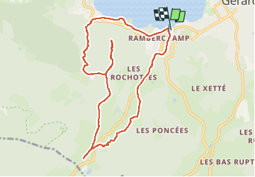

Length
9.7 km

Max alt
891 m

Uphill gradient
334 m
Km-Effort
14.2 km

Min alt
658 m

Downhill gradient
351 m
Boucle
Yes
Creation date :
2023-05-29 12:38:16.322
Updated on :
2023-05-30 09:51:08.454
2h32
Difficulty : Difficult

FREE GPS app for hiking
 SityTrail
IGN / Geographical institutes
SityTrail Plus
The world is yours!
About
Trail Walking of 9.7 km to be discovered at Grand Est, Vosges, Gérardmer. This trail is proposed by claudel.
Positioning
Country:
France
Region :
Grand Est
Department/Province :
Vosges
Municipality :
Gérardmer
Location:
Unknown
Start:(Dec)
Start:(UTM)
340396 ; 5325804 (32U) N.
Comments