


Landévennec

xcreator
User
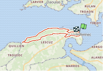

Length
13.2 km

Max alt
108 m

Uphill gradient
294 m
Km-Effort
17 km

Min alt
0 m

Downhill gradient
279 m
Boucle
No
Creation date :
2023-05-30 08:40:52.519
Updated on :
2023-05-30 13:31:33.066
4h49
Difficulty : Difficult

FREE GPS app for hiking
 SityTrail
IGN / Geographical institutes
SityTrail Plus
The world is yours!
About
Trail Walking of 13.2 km to be discovered at Brittany, Finistère, Landévennec. This trail is proposed by xcreator.
Photos


Positioning
Country:
France
Region :
Brittany
Department/Province :
Finistère
Municipality :
Landévennec
Location:
Unknown
Start:(Dec)
Start:(UTM)
405931 ; 5349756 (30U) N.
Comments