


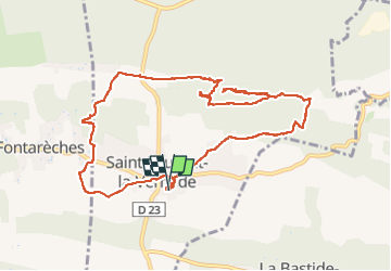
2023.06.01 - Saint-Laurent-de-la-Vernède

rando30129
User

Length
12 km

Max alt
278 m

Uphill gradient
196 m
Km-Effort
14.6 km

Min alt
205 m

Downhill gradient
195 m
Boucle
Yes
Creation date :
2023-06-01 07:06:48.0
Updated on :
2023-06-01 10:49:57.976
3h41
Difficulty : Difficult

FREE GPS app for hiking
 SityTrail
IGN / Geographical institutes
SityTrail Plus
The world is yours!
About
Trail Walking of 12 km to be discovered at Occitania, Gard, Saint-Laurent-la-Vernède. This trail is proposed by rando30129.
Positioning
Country:
France
Region :
Occitania
Department/Province :
Gard
Municipality :
Saint-Laurent-la-Vernède
Location:
Unknown
Start:(Dec)
Start:(UTM)
616706 ; 4884518 (31T) N.
Comments