


Col du Fût d’Avenas (16km - D. 533 m)

Thomasdanielle
User
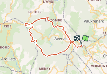

Length
16.1 km

Max alt
887 m

Uphill gradient
534 m
Km-Effort
23 km

Min alt
537 m

Downhill gradient
539 m
Boucle
Yes
Creation date :
2023-06-01 06:58:20.0
Updated on :
2025-05-18 08:51:22.948
5h17
Difficulty : Very difficult

FREE GPS app for hiking
 SityTrail
IGN / Geographical institutes
SityTrail Plus
The world is yours!
About
Trail Walking of 16.1 km to be discovered at Auvergne-Rhône-Alpes, Rhône, Chiroubles. This trail is proposed by Thomasdanielle.
Description
D/A : Parking en haut sur la droite après le restaurant
Positioning
Country:
France
Region :
Auvergne-Rhône-Alpes
Department/Province :
Rhône
Municipality :
Chiroubles
Location:
Unknown
Start:(Dec)
Start:(UTM)
625702 ; 5116459 (31T) N.
Comments