


Cabane de Conques

chasle
User
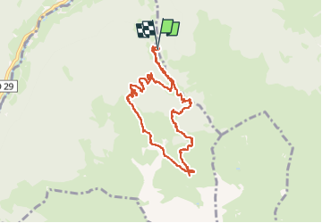

Length
10 km

Max alt
1721 m

Uphill gradient
754 m
Km-Effort
20 km

Min alt
1051 m

Downhill gradient
752 m
Boucle
Yes
Creation date :
2023-06-01 06:26:28.902
Updated on :
2023-06-01 17:09:06.87
3h22
Difficulty : Difficult

FREE GPS app for hiking
 SityTrail
IGN / Geographical institutes
SityTrail Plus
The world is yours!
About
Trail Walking of 10 km to be discovered at Occitania, Hautespyrenees, Campan. This trail is proposed by chasle.
Positioning
Country:
France
Region :
Occitania
Department/Province :
Hautespyrenees
Municipality :
Campan
Location:
Unknown
Start:(Dec)
Start:(UTM)
266898 ; 4763543 (31T) N.
Comments