


balade pédestre 1 juin 2023

gilbertdu60
User
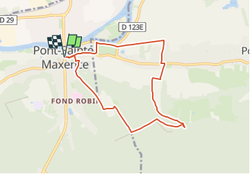

Length
7.4 km

Max alt
130 m

Uphill gradient
130 m
Km-Effort
9.2 km

Min alt
28 m

Downhill gradient
130 m
Boucle
Yes
Creation date :
2023-06-01 18:24:03.47
Updated on :
2023-06-01 18:25:52.241
2h04
Difficulty : Easy

FREE GPS app for hiking
 SityTrail
IGN / Geographical institutes
SityTrail Plus
The world is yours!
About
Trail On foot of 7.4 km to be discovered at Hauts-de-France, Oise, Pont-Sainte-Maxence. This trail is proposed by gilbertdu60.
Description
un tour par la campagne et la forêt
Positioning
Country:
France
Region :
Hauts-de-France
Department/Province :
Oise
Municipality :
Pont-Sainte-Maxence
Location:
Unknown
Start:(Dec)
Start:(UTM)
471260 ; 5461019 (31U) N.
Comments