


Pont de Joux à Collet Redon

ARPF
User
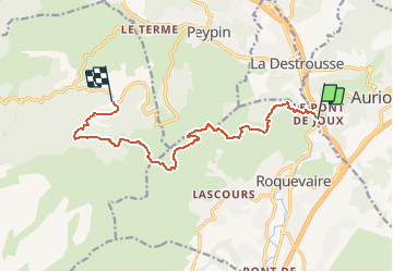

Length
12 km

Max alt
627 m

Uphill gradient
563 m
Km-Effort
18.8 km

Min alt
173 m

Downhill gradient
352 m
Boucle
No
Creation date :
2014-12-10 00:00:00.0
Updated on :
2014-12-10 00:00:00.0
4h05
Difficulty : Medium
FREE GPS app for hiking
 SityTrail
IGN / Geographical institutes
SityTrail Plus
The world is yours!
About
Trail Walking of 12 km to be discovered at Provence-Alpes-Côte d'Azur, Bouches-du-Rhône, Roquevaire. This trail is proposed by ARPF.
Positioning
Country:
France
Region :
Provence-Alpes-Côte d'Azur
Department/Province :
Bouches-du-Rhône
Municipality :
Roquevaire
Location:
Unknown
Start:(Dec)
Start:(UTM)
711664 ; 4804522 (31T) N.
Comments