


NAV en DA20 LFQW-LFQM-LFEV-LFQW

nicolasdresse
User
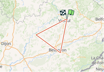

Length
146 km

Max alt
576 m

Uphill gradient
3837 m
Km-Effort
197 km

Min alt
188 m

Downhill gradient
3832 m
Boucle
No
Creation date :
2023-06-02 11:25:40.672
Updated on :
2023-06-18 13:31:45.47
0m
Difficulty : Very easy

FREE GPS app for hiking
 SityTrail
IGN / Geographical institutes
SityTrail Plus
The world is yours!
About
Trail Plane of 146 km to be discovered at Bourgogne-Franche-Comté, Haute-Saône, Comberjon. This trail is proposed by nicolasdresse.
Description
Navigation triangulaire classique
Positioning
Country:
France
Region :
Bourgogne-Franche-Comté
Department/Province :
Haute-Saône
Municipality :
Comberjon
Location:
Unknown
Start:(Dec)
Start:(UTM)
290024 ; 5279864 (32T) N.
Comments