


gpx combeau VR

dorane
User
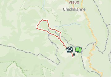

Length
11 km

Max alt
1947 m

Uphill gradient
527 m
Km-Effort
18 km

Min alt
1449 m

Downhill gradient
527 m
Boucle
Yes
Creation date :
2023-06-02 11:34:55.674
Updated on :
2023-06-02 11:34:55.674
4h06
Difficulty : Difficult

FREE GPS app for hiking
 SityTrail
IGN / Geographical institutes
SityTrail Plus
The world is yours!
About
Trail Walking of 11 km to be discovered at Auvergne-Rhône-Alpes, Drôme, Châtillon-en-Diois. This trail is proposed by dorane.


Positioning
Country:
France
Region :
Auvergne-Rhône-Alpes
Department/Province :
Drôme
Municipality :
Châtillon-en-Diois
Location:
Treschenu-Creyers
Start:(Dec)
Start:(UTM)
703631 ; 4961056 (31T) N.
Comments