


OliveGranon

Léger Michel
User

Length
46 km

Max alt
2410 m

Uphill gradient
1405 m
Km-Effort
65 km

Min alt
1206 m

Downhill gradient
1405 m
Boucle
Yes
Creation date :
2023-06-02 07:28:11.957
Updated on :
2023-06-02 13:34:05.554
6h04
Difficulty : Very difficult

FREE GPS app for hiking
 SityTrail
IGN / Geographical institutes
SityTrail Plus
The world is yours!
About
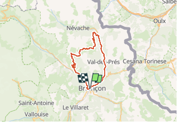
Trail Mountain bike of 46 km to be discovered at Provence-Alpes-Côte d'Azur, Hautes-Alpes, Briançon. This trail is proposed by Léger Michel.
Positioning
Country:
France
Region :
Provence-Alpes-Côte d'Azur
Department/Province :
Hautes-Alpes
Municipality :
Briançon
Location:
Unknown
Start:(Dec)
Start:(UTM)
313471 ; 4974198 (32T) N.
Comments