


ste Suzanne Charmes.

xst
User
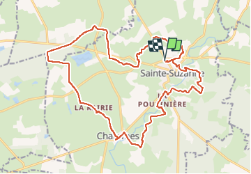

Length
23 km

Max alt
204 m

Uphill gradient
311 m
Km-Effort
27 km

Min alt
85 m

Downhill gradient
311 m
Boucle
Yes
Creation date :
2023-06-02 13:57:53.526
Updated on :
2023-06-02 16:07:00.933
2h08
Difficulty : Medium

FREE GPS app for hiking
 SityTrail
IGN / Geographical institutes
SityTrail Plus
The world is yours!
About
Trail Mountain bike of 23 km to be discovered at Pays de la Loire, Mayenne, Sainte-Suzanne-et-Chammes. This trail is proposed by xst.
Description
un peu difficile au début, puis cool. Ne pas faire par temps humide.
Positioning
Country:
France
Region :
Pays de la Loire
Department/Province :
Mayenne
Municipality :
Sainte-Suzanne-et-Chammes
Location:
Unknown
Start:(Dec)
Start:(UTM)
696815 ; 5330965 (30U) N.
Comments