


Vosges Lac Blanc Noir Forlet Vert

c.gourme
User

Length
17.7 km

Max alt
1304 m

Uphill gradient
694 m
Km-Effort
27 km

Min alt
950 m

Downhill gradient
693 m
Boucle
Yes
Creation date :
2023-06-03 07:30:49.0
Updated on :
2023-06-18 14:25:08.082
6h44
Difficulty : Medium

FREE GPS app for hiking
 SityTrail
IGN / Geographical institutes
SityTrail Plus
The world is yours!
About
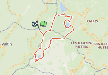
Trail Walking of 17.7 km to be discovered at Grand Est, Vosges, Le Valtin. This trail is proposed by c.gourme.
Positioning
Country:
France
Region :
Grand Est
Department/Province :
Vosges
Municipality :
Le Valtin
Location:
Unknown
Start:(Dec)
Start:(UTM)
355899 ; 5330222 (32U) N.
Comments