


Trace lac de Soum G4 Guy

mitch1952
User
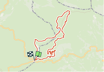

Length
10.2 km

Max alt
1602 m

Uphill gradient
233 m
Km-Effort
13.3 km

Min alt
1432 m

Downhill gradient
232 m
Boucle
Yes
Creation date :
2023-06-02 07:18:52.0
Updated on :
2023-06-04 14:06:02.405
4h32
Difficulty : Unknown

FREE GPS app for hiking
 SityTrail
IGN / Geographical institutes
SityTrail Plus
The world is yours!
About
Trail Walking of 10.2 km to be discovered at Occitania, Hautespyrenees, Arbéost. This trail is proposed by mitch1952.
Positioning
Country:
France
Region :
Occitania
Department/Province :
Hautespyrenees
Municipality :
Arbéost
Location:
Unknown
Start:(Dec)
Start:(UTM)
723414 ; 4760129 (30T) N.
Comments