


saint Dalmas

taguette
User
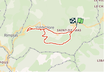

Length
15.6 km

Max alt
1358 m

Uphill gradient
648 m
Km-Effort
24 km

Min alt
822 m

Downhill gradient
647 m
Boucle
Yes
Creation date :
2023-06-03 06:16:13.386
Updated on :
2023-06-04 15:12:22.674
4h08
Difficulty : Difficult

FREE GPS app for hiking
 SityTrail
IGN / Geographical institutes
SityTrail Plus
The world is yours!
About
Trail Walking of 15.6 km to be discovered at Provence-Alpes-Côte d'Azur, Maritime Alps, Valdeblore. This trail is proposed by taguette.
Positioning
Country:
France
Region :
Provence-Alpes-Côte d'Azur
Department/Province :
Maritime Alps
Municipality :
Valdeblore
Location:
Unknown
Start:(Dec)
Start:(UTM)
356624 ; 4881281 (32T) N.
Comments