


live Saint Côme - Estaing

djeepee74
User
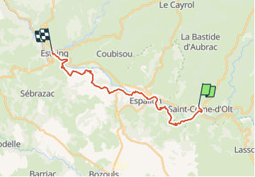

Length
22 km

Max alt
523 m

Uphill gradient
544 m
Km-Effort
29 km

Min alt
312 m

Downhill gradient
589 m
Boucle
No
Creation date :
2023-06-04 06:18:17.003
Updated on :
2023-06-09 14:30:03.419
6h37
Difficulty : Difficult

FREE GPS app for hiking
 SityTrail
IGN / Geographical institutes
SityTrail Plus
The world is yours!
About
Trail Walking of 22 km to be discovered at Occitania, Aveyron, Saint-Côme-d'Olt. This trail is proposed by djeepee74.
Photos


28 photos in total. Please click on a photo to see them all in the gallery.
Positioning
Country:
France
Region :
Occitania
Department/Province :
Aveyron
Municipality :
Saint-Côme-d'Olt
Location:
Unknown
Start:(Dec)
Start:(UTM)
485149 ; 4929269 (31T) N.
Comments