


Archelange

pje
User
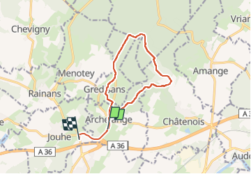

Length
12 km

Max alt
364 m

Uphill gradient
203 m
Km-Effort
14.8 km

Min alt
233 m

Downhill gradient
226 m
Boucle
No
Creation date :
2023-06-05 07:02:20.883
Updated on :
2023-06-05 09:59:00.801
2h56
Difficulty : Easy

FREE GPS app for hiking
 SityTrail
IGN / Geographical institutes
SityTrail Plus
The world is yours!
About
Trail Walking of 12 km to be discovered at Bourgogne-Franche-Comté, Jura, Archelange. This trail is proposed by pje.
Description
Randonnée
Positioning
Country:
France
Region :
Bourgogne-Franche-Comté
Department/Province :
Jura
Municipality :
Archelange
Location:
Unknown
Start:(Dec)
Start:(UTM)
690591 ; 5224147 (31T) N.
Comments