


Trace Ferrieres G3 Guy

mitch1952
User
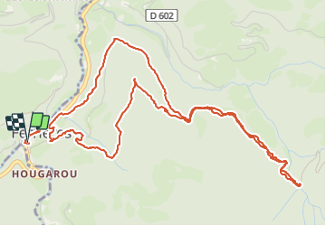

Length
7.9 km

Max alt
975 m

Uphill gradient
484 m
Km-Effort
14.3 km

Min alt
541 m

Downhill gradient
484 m
Boucle
Yes
Creation date :
2023-06-05 09:10:51.0
Updated on :
2023-06-05 12:39:41.498
3h27
Difficulty : Unknown

FREE GPS app for hiking
 SityTrail
IGN / Geographical institutes
SityTrail Plus
The world is yours!
About
Trail Walking of 7.9 km to be discovered at Occitania, Hautespyrenees, Ferrières. This trail is proposed by mitch1952.
Positioning
Country:
France
Region :
Occitania
Department/Province :
Hautespyrenees
Municipality :
Ferrières
Location:
Unknown
Start:(Dec)
Start:(UTM)
722962 ; 4765593 (30T) N.
Comments