Trail Walking Châteauneuf-Miravail - Tour de la Montagne de Saint Michel + Le Pousterlon Via St Vincent / Jabron - Photo

Tour de la Montagne de Saint Michel + Le Pousterlon Via St Vincent / Jabron

© OpenStreetMap contributors
Length
Length
12.2 km
Max alt
Max alt
1173 m
Uphill gradient
Uphill gradient
656 m
Km-Effort
Km-Effort  
21 km
Min alt
Min alt
624 m
Downhill gradient
Downhill gradient
624 m
Boucle
Boucle
No
Creation date :
2023-05-30 07:23:26.522
Updated on :
2024-05-29 13:35:00.434

(0 Reviews)

Walking
Walking
4h43
Difficulty : Very difficult

Scan this QR Code to open this trail in the SityTrail application

FREE GPS app for hiking

Logo SityTrail SityTrail

IGN / Geographical institutes

Download SityTrail from the App Store Download SityTrail from Google Play

Logo SityTrail SityTrail World

The world is yours!

Download SityTrail from the App Store Download SityTrail from Google Play Download SityTrail on Huawei AppGallery

About

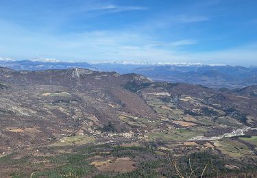
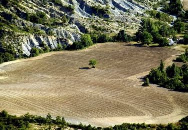
Trail Walking of 12.2 km to be discovered at Provence-Alpes-Côte d'Azur, Alpes-de-Haute-Provence, Châteauneuf-Miravail. This trail is proposed by PapouBertrand.

Description

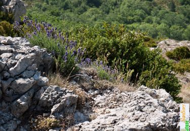
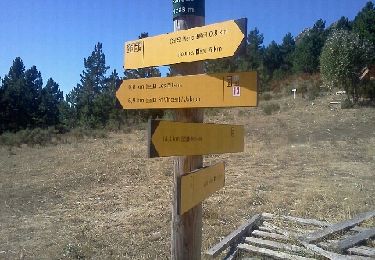
Attention le Pousterlon difficile d'accès et sentier très difficile à trouver et végétation très dense...
Passage par la Parandière déconseillé.

Elevation profile

Positioning

Country:
France
Region :
Provence-Alpes-Côte d'Azur
Department/Province :
Alpes-de-Haute-Provence
Municipality :
Châteauneuf-Miravail
Location:
Unknown
Start:(UTM)
719581 ; 4894029 (31T) N.

Trails nearby

Trail Walking Saint-Vincent-sur-Jabron - Traversée de la Montagne de Mare depuis Aubard - Photo
Walking
tracegps

Walking

Easy
(1)
Saint-Vincent-sur-Jabron, Provence-Alpes-Côte d'Azur, Alpes-de-Haute-Provence, France
13.3 km | 23 km-effort
5h 45min
Yes
Trail Walking Noyers-sur-Jabron - Pas du long Rocher - Montagne de Pélegrine - Pas des portes 18/02/24 - Photo
Walking
GUIDE
R@ph

Walking

Very difficult
Noyers-sur-Jabron, Provence-Alpes-Côte d'Azur, Alpes-de-Haute-Provence, France
19.3 km | 32 km-effort
7h 15min
Yes
Trail Walking Saint-Vincent-sur-Jabron - Crête Montagne de Mare Via St Vincent sur Jabron - Photo
Walking
PapouBertrand

Walking

Very difficult
Saint-Vincent-sur-Jabron, Provence-Alpes-Côte d'Azur, Alpes-de-Haute-Provence, France
14.8 km | 25 km-effort
5h 44min
Yes
Trail Walking Noyers-sur-Jabron - SityTrail - NOYERS SUR JABRON  , S Martin  , col S Pierre , cretes de l ane n - Photo
Walking
Marco05

Walking

Difficult
Noyers-sur-Jabron, Provence-Alpes-Côte d'Azur, Alpes-de-Haute-Provence, France
13.3 km | 24 km-effort
5h 28min
Yes
Trail Walking Saint-Vincent-sur-Jabron - SAINT VINCENT DU JABRON.  Aubard,  col de Verdun , le pied du mulet o l m s  - Photo
Walking
RobinMicheline

Walking

Medium
Saint-Vincent-sur-Jabron, Provence-Alpes-Côte d'Azur, Alpes-de-Haute-Provence, France
13.3 km | 23 km-effort
3h 48min
Yes
Trail Walking Saint-Vincent-sur-Jabron - SAINT VINCENT SUR JABRON. Pas de Parandier  ,montagne S Michel o n - Photo
Walking
RobinMicheline

Walking

Medium
Saint-Vincent-sur-Jabron, Provence-Alpes-Côte d'Azur, Alpes-de-Haute-Provence, France
14.4 km | 23 km-effort
4h 13min
Yes
Trail Running Noyers-sur-Jabron - La Faïrotte - Photo
Running
tracegps

Running

Medium
Noyers-sur-Jabron, Provence-Alpes-Côte d'Azur, Alpes-de-Haute-Provence, France
11.6 km | 17.3 km-effort
1h 30min
Yes
Trail Walking Noyers-sur-Jabron - La Faïrotte - Photo
Walking
tracegps

Walking

Difficult
Noyers-sur-Jabron, Provence-Alpes-Côte d'Azur, Alpes-de-Haute-Provence, France
11.6 km | 17.3 km-effort
3h 30min
Yes
Trail Running Noyers-sur-Jabron - La Faïrotte (1288 m) - Photo
Running
phd04

Running

Easy
Noyers-sur-Jabron, Provence-Alpes-Côte d'Azur, Alpes-de-Haute-Provence, France
12.2 km | 17.9 km-effort
1h 41min
Yes


Close
My subscriptions