


pied de birne

lionelnottat
User
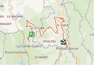

Length
19.5 km

Max alt
925 m

Uphill gradient
274 m
Km-Effort
25 km

Min alt
321 m

Downhill gradient
801 m
Boucle
No
Creation date :
2023-05-31 07:36:49.977
Updated on :
2023-06-05 17:15:48.167
5h13
Difficulty : Very difficult

FREE GPS app for hiking
 SityTrail
IGN / Geographical institutes
SityTrail Plus
The world is yours!
About
Trail Walking of 19.5 km to be discovered at Occitania, Lozère, Prévenchères. This trail is proposed by lionelnottat.
Positioning
Country:
France
Region :
Occitania
Department/Province :
Lozère
Municipality :
Prévenchères
Location:
Unknown
Start:(Dec)
Start:(UTM)
574250 ; 4925962 (31T) N.
Comments