Trail Nordic walking Chardonne - plein ciel  - Photo
© OpenStreetMap contributors
Length
Length
6.2 km
Max alt
Max alt
1107 m
Uphill gradient
Uphill gradient
281 m
Km-Effort
Km-Effort  
9.9 km
Min alt
Min alt
852 m
Downhill gradient
Downhill gradient
271 m
Boucle
Boucle
Yes
Creation date :
2023-06-06 08:58:42.233
Updated on :
2023-06-06 11:20:05.367

(0 Reviews)

Nordic walking
Nordic walking
2h16
Difficulty : Very easy

Scan this QR Code to open this trail in the SityTrail application

FREE GPS app for hiking

Logo SityTrail SityTrail

IGN / Geographical institutes

Download SityTrail from the App Store Download SityTrail from Google Play

Logo SityTrail SityTrail World

The world is yours!

Download SityTrail from the App Store Download SityTrail from Google Play Download SityTrail on Huawei AppGallery

About

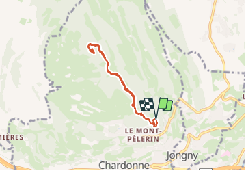
Trail Nordic walking of 6.2 km to be discovered at Vaud, District de la Riviera-Pays-d’Enhaut, Chardonne. This trail is proposed by suzanne.bron.

Elevation profile

Photos

Positioning

Country:
Switzerland
Region :
Vaud
Department/Province :
District de la Riviera-Pays-d’Enhaut
Municipality :
Chardonne
Location:
Unknown
Start:(UTM)
333848 ; 5150204 (32T) N.

Trails nearby

Trail Cycle Vevey - Vevey - Nyon - Photo
Cycle
karawatsj

Cycle

Difficult
Vevey, Vaud, District de la Riviera-Pays-d’Enhaut, Switzerland
70 km | 82 km-effort
7h 11min
No
Trail Other activity Châtel-Saint-Denis - y10_chatel_vevey - Photo
Other activity
GUIDE+

Other activity

Very easy
Châtel-Saint-Denis, Fribourg, District de la Veveyse, Switzerland
9.8 km | 12.4 km-effort
2h 46min
No
Trail Other activity Chardonne - y10_mont_pellerin - Photo
Other activity
GUIDE+

Other activity

Very easy
Chardonne, Vaud, District de la Riviera-Pays-d’Enhaut, Switzerland
9.1 km | 13.4 km-effort
2h 55min
Yes
Trail Walking Saint-Saphorin (Lavaux) - w10_01_lavaux - Photo
Walking
GUIDE+

Walking

Very easy
(2)
Saint-Saphorin (Lavaux), Vaud, District de Lavaux-Oron, Switzerland
11.1 km | 15.2 km-effort
3h 52min
No
Trail Cycle La Tour-de-Peilz - Vom Genfersee an den Bodensee - Photo
Cycle
GUIDE+

Cycle

Very easy
La Tour-de-Peilz, Vaud, District de la Riviera-Pays-d’Enhaut, Switzerland
302 km | 466 km-effort
123h 6min
No
Trail Walking Chexbres - Chexbres: Balade dans le vignoble - Photo
Walking
GUIDE+

Walking

Very easy
Chexbres, Vaud, District de Lavaux-Oron, Switzerland
4.7 km | 6.6 km-effort
Unknown
No
Trail Walking La Tour-de-Peilz - st_korea_tv1 - Photo
Walking
GUIDE+

Walking

Very easy
La Tour-de-Peilz, Vaud, District de la Riviera-Pays-d’Enhaut, Switzerland
428 km | 1002 km-effort
29h 5min
No
Trail Walking La Tour-de-Peilz - st_ral_08_5 - Photo
Walking
GUIDE+

Walking

Very easy
La Tour-de-Peilz, Vaud, District de la Riviera-Pays-d’Enhaut, Switzerland
116 km | 154 km-effort
6h 55min
No
Trail On foot Chardonne - Sentier des Narcisses, Le Mont-Pèlerin - Photo
On foot
famiski

On foot

Easy
Chardonne, Vaud, District de la Riviera-Pays-d’Enhaut, Switzerland
8.9 km | 13.8 km-effort
3h 8min
Yes


Close
My subscriptions