


Reconnaissance fontaine salée depuis Charente

Chabard
User
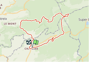

Length
21 km

Max alt
1727 m

Uphill gradient
764 m
Km-Effort
31 km

Min alt
1163 m

Downhill gradient
765 m
Boucle
Yes
Creation date :
2023-06-06 07:03:21.0
Updated on :
2023-06-06 11:47:10.272
4h43
Difficulty : Difficult

FREE GPS app for hiking
 SityTrail
IGN / Geographical institutes
SityTrail Plus
The world is yours!
About
Trail Walking of 21 km to be discovered at Auvergne-Rhône-Alpes, Puy-de-Dôme, Picherande. This trail is proposed by Chabard.
Description
Reconnaissance fontaine salée depuis Chareire
Positioning
Country:
France
Region :
Auvergne-Rhône-Alpes
Department/Province :
Puy-de-Dôme
Municipality :
Picherande
Location:
Unknown
Start:(Dec)
Start:(UTM)
482762 ; 5036741 (31T) N.
Comments