


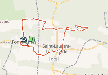
2023.06.06. - Fontarèches, St-Laurent-la-Vernède

rando30129
User

Length
13.1 km

Max alt
282 m

Uphill gradient
215 m
Km-Effort
15.9 km

Min alt
213 m

Downhill gradient
215 m
Boucle
Yes
Creation date :
2023-06-06 07:03:57.0
Updated on :
2023-06-06 21:13:20.367
4h46
Difficulty : Difficult

FREE GPS app for hiking
 SityTrail
IGN / Geographical institutes
SityTrail Plus
The world is yours!
About
Trail Walking of 13.1 km to be discovered at Occitania, Gard, Fontarèches. This trail is proposed by rando30129.
Positioning
Country:
France
Region :
Occitania
Department/Province :
Gard
Municipality :
Fontarèches
Location:
Unknown
Start:(Dec)
Start:(UTM)
615248 ; 4884838 (31T) N.
Comments