


Otranto

antignacs
User GUIDE
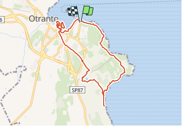

Length
10.8 km

Max alt
57 m

Uphill gradient
140 m
Km-Effort
12.7 km

Min alt
-2 m

Downhill gradient
139 m
Boucle
Yes
Creation date :
2023-06-06 08:35:20.0
Updated on :
2023-07-01 15:34:09.262
4h42
Difficulty : Very easy

FREE GPS app for hiking
 SityTrail
IGN / Geographical institutes
SityTrail Plus
The world is yours!
About
Trail Walking of 10.8 km to be discovered at Apulia, Lecce, Otranto. This trail is proposed by antignacs.
Photos


Positioning
Country:
Italy
Region :
Apulia
Department/Province :
Lecce
Municipality :
Otranto
Location:
Unknown
Start:(Dec)
Start:(UTM)
286936 ; 4447072 (34T) N.
Comments