


Saint Cirq à Cabrerets

dominiq
User
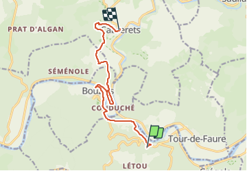

Length
11.7 km

Max alt
339 m

Uphill gradient
424 m
Km-Effort
17.7 km

Min alt
127 m

Downhill gradient
524 m
Boucle
No
Creation date :
2023-06-06 06:02:13.0
Updated on :
2023-06-09 19:50:13.162
3h40
Difficulty : Medium

FREE GPS app for hiking
 SityTrail
IGN / Geographical institutes
SityTrail Plus
The world is yours!
About
Trail Walking of 11.7 km to be discovered at Occitania, Lot, Saint-Cirq-Lapopie. This trail is proposed by dominiq.
Description
Sur le parcours, ne pas manquer la visite de la grotte de Pech Merle. Ce n'est pas une reconstitution mais bien la grotte originale.
Photos


Positioning
Country:
France
Region :
Occitania
Department/Province :
Lot
Municipality :
Saint-Cirq-Lapopie
Location:
Unknown
Start:(Dec)
Start:(UTM)
394006 ; 4924222 (31T) N.
Comments