


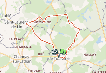
Courcelles-de-Touraine - 15.6km 110m 4h05 (45mn) - 2023 06 07

Orcal37
User GUIDE

Length
15.6 km

Max alt
115 m

Uphill gradient
112 m
Km-Effort
17.1 km

Min alt
76 m

Downhill gradient
112 m
Boucle
Yes
Creation date :
2023-06-07 08:21:23.095
Updated on :
2023-06-07 18:33:41.884
4h05
Difficulty : Easy

FREE GPS app for hiking
 SityTrail
IGN / Geographical institutes
SityTrail Plus
The world is yours!
About
Trail Walking of 15.6 km to be discovered at Centre-Loire Valley, Indre-et-Loire, Courcelles-de-Touraine. This trail is proposed by Orcal37.
Description
Courcelles-de-Touraine - 15.6km 110m 4h05 (45mn) - 2023 06 07
Photos
 - 2023 06 07 - Photo 1")
 - 2023 06 07 - Photo 2")
 - 2023 06 07 - Photo 3")
 - 2023 06 07 - Photo 4")
 - 2023 06 07 - Photo 5")
 - 2023 06 07 - Photo 6")
 - 2023 06 07 - Photo 7")
 - 2023 06 07 - Photo 8")
 - 2023 06 07 - Photo 9")
Positioning
Country:
France
Region :
Centre-Loire Valley
Department/Province :
Indre-et-Loire
Municipality :
Courcelles-de-Touraine
Location:
Unknown
Start:(Dec)
Start:(UTM)
297153 ; 5262110 (31T) N.
Comments